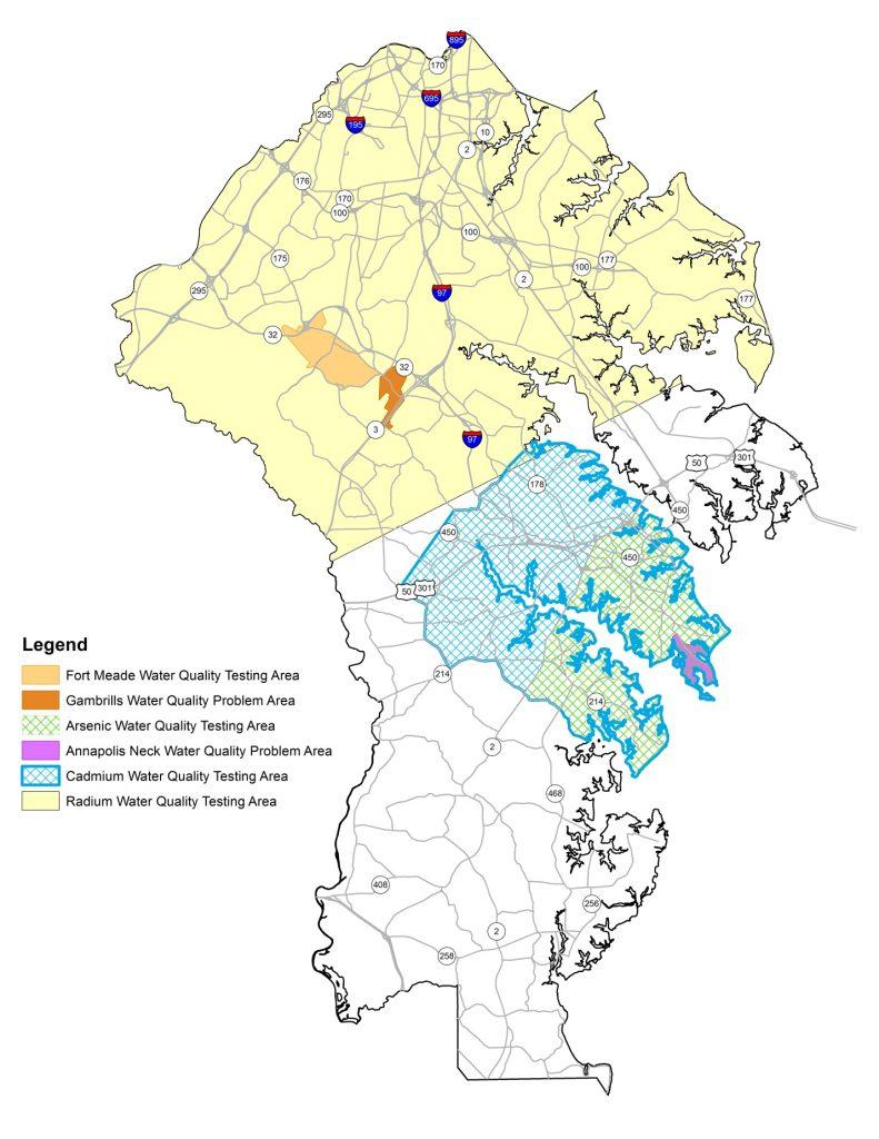
The Anne Arundel County Department of Health has identified five potential groundwater problem areas within the county, shown in the figure below. These problem areas are due to saltwater intrusion, volatile organic compounds (VOCs) and elevated levels of nitrate, radium, arsenic and cadmium. The Department of Health will monitor these areas and, if petitions are submitted for service, action will be taken accordingly, in conjunction with the Office of Planning and Zoning. The five groundwater problem areas are Annapolis Neck, Gambrills Area, Northern Anne Arundel County (generally all areas north of U.S. Route 50), Fort Meade/Odenton Area and the Annapolis/Edgewater Peninsula.
Annapolis Neck – Salt Water Intrusion
New wells in this area are required to be drilled and grouted (sealed) into a confined aquifer, which is screened at a depth of no less than 270 feet and grouted to a depth of no less than 200 feet to avoid saltwater intrusion problems.
Gambrills Area – Elevated Nitrate Levels
Elevated nitrate levels have been detected in some private wells in the Gambrills area near the intersection of Annapolis Road (Route 175) and Robert Crain Highway (Route 3), just east of the Horizons Farm (the recent U.S. Naval Academy Dairy Farm). New wells in this area are required to be drilled and sealed into a confined aquifer below 140 feet in depth to avoid nitrate problems.
Northern Anne Arundel County – Elevated Radium Levels
New and replacement wells in Northern Anne Arundel County are required to be installed to a minimum well depth and meet gross alpha and radium 226/228 drinking water standards. The figure below illustrates the region where these parameters are tested. A minimum well depth is determined by the Department of Health and is based on an aquifer with acceptable radionuclide concentrations. A computer model showing the distribution of radionuclide data, well depths, property elevations and deep test wells is used to determine the minimum well depth requirements. Owners of existing private wells are encouraged to test for gross alpha particles. Where levels are found above the drinking water standards, a water treatment unit or a replacement well in a deeper aquifer is recommended.
Lower Patapsco Aquifer adjacent to Ft. Meade
A remedial investigation/feasibility study (RI/FS) identified three groundwater contaminant plumes within the Lower Patapsco Aquifer (LPA) that extends beyond the Ft. Meade boundary and into an area beneath the town of Odenton. The identified contaminants were trichloroethene (TCE), tetrachloroethene (PCE) and carbon tetrachloroethene (CC14). To mitigate the impact on groundwater, a groundwater remediation system (GRS) was placed into service in March 2014. The GRS is estimated to take 25 years to restore the LPA to drinking water standards. If a property is located within the LPA assessment area and public water is not available, Appendix J of the RI/FS provides remedial alternatives for:
- The continued use and long-term monitoring (LTM) of existing potable wells within the LPA or an unknown aquifer and a point of entry treatment system (POET).
- A risk evaluation for replacement wells in the Upper Patapsco Aquifer (UPA) and a water treatment device for radium where levels are found above the safe drinking water standard.
- A property assessment for single lot and subdivision development in relation to the plumes and availability of public water.
As part of the RI/FS, the Army will perform a cost benefit analysis every five years for LTM and operation and maintenance (O&M) of a POET system to extend public water where a cluster of three or more properties exist within the same geographic area. Where the LTM and O&M costs exceed the cost of extending public water, the Army must develop plans to extend public water within the five-year LPA study assessment period. Extension of public water will follow the development of plans and will be limited to an impacted property or cluster of properties based on the cost benefit analysis. The interim requirements for the construction of a replacement well in the UPA include the following:
- The well must be drilled and sealed into the Upper Patapsco aquifer at a depth no greater than 200 feet below the land surface.
- The annular space must be grouted from the gravel pack to the land surface, and the gravel pack may not extend more than five feet above the well screen level.
Annapolis/Edgewater Peninsula – Presence of Elevated Arsenic and Cadmium
Wells drilled in this area may show a presence of arsenic and cadmium with levels that exceed the EPA maximum contaminant level (MCL). The presence of these chemicals occurs in wells drilled in the Aquia Aquifer. Any well drilled that exceeds the MCL for arsenic must be redrilled to a different depth. All new and replacement wells located specifically in the Saunders Point Community must meet a minimum well depth of 300 feet. All other wells in the test area that exceed the MCL for cadmium may be granted a Conditional Certificate of Potability with a water treatment system.